|
A Chronological Survey Of Some Of The Historical
Happenings In South Lake County And Its Surroundings By: Bill
Wink © 2024 Please note* Do to the ‘volume’ of this information,
it is spread over 3 pages. This is page #1 CONTENTS: EVENTS The
Clear Lake Volcanics The
Mayacamas Mountains Naming
Mt Saint Helena 1841 Wennoks Alta
California Rancho
de Collayomi 1844 Robert
T. Ridley Rancho
de Guenoc 1845 Jacob
Primer Leese Loconoma
Valley Long
Valley Guenoc
Valley Coyote
Valley Putah
Creek Gold!
1848 The
First Road Into Lake County 1850 “The
Bloody Island Massacre” Ritchie
And Forbes 1852 First
Settlers in Coyote Valley 1852 James
Harbin 1856 McKinley
Mill Springston
1857 Alexander
Houston Butts 1857 Kayote
1859 The
Village of Guenoc 1860 Herrick
& Getz 1860 Cinnabar
Discovered 1860 Hamlin
Nelson Herrick 1860 John
Brandt 1860 Joseph
Getz 1860 Lake
County Formed in 1861 The
Journal of William H. Brewer James
M. Finley 1862 Lorenzo
Bonaparte Church The
Homestead Act of 1862 Lawley
Toll Road 1866 William
H. Thompson 1866 B.
F. English 1867 1870
Gives Birth To Middletown Adams
Springs 1871 First
Mountain Mill House before McNulty 1871 McNulty’s
Mountain Mill House 1873 Anderson
Springs 1873 Great
Western Mine 1873 The
Great Western Sawmill The
Bradford 1873 Middletown
Builds School House 1874 Telegraph
Line 1874 Joseph
L. Read 1874 Ida
Clayton and Great Western Turnpike Toll Road 1874 C
M Young To Build Hotel 1875 The
Odd Fellows of Middletown 1875 Shooting
of ‘Uncle Mike Ready’ 1875 Lake
County House 1875 Shoot
Out In Middletown 1875 Andrew
Rocca 1876 Thomas
Kearney Dye 1878 Robert
Louis Stevenson 1880 Theron
Ink Builds Round Corrals 1880 Diphtheria
In The Middletown Area 1883 Hoberg’s
Resort 1885 Middletown
Independent Established 1886 Jim
Davis 1886 Lillie
Langtry 1888 Middletown
Cemetery 1889 The
California White Cap Murders 1890 The
White House 21048 Calistoga Street C.1891 Quicksilver
Mine Sold 1891 The
Middletown Methodist Episcopal Church 1893 Buck
English – Outlaw 1895 Fire
Middletown December 20, 1895 Andrew
B. McCreery 1896 Mrs.
Langtry Divorced 1897 George
Coburn 1897 Whispering
Pines 1900 “Dry”
Votes Win In Lake County 1908 Strange
Deaths At Middletown 1908 Middletown
Rancheria 1910 The
Murder Of Ham Herrick 1914 Middletown
Is Burning! 1918 The
Lake County House Is No More 1918 New
Herrick Hotel April 1920 William
Ferdinand Detert 1920 Middletown
Times Star 1928 Twelve
Years After The Spier’s Fire 1930 M.
V. F. D. 1930 Middletown
Luncheon Club 1930 The
Corner Store started 1943 Guenoc
Rancho Detert to Woodland Farms 1952 Rotary
Dial Phone Service Came to Middletown Saturday November 2, 1957 Middletown
Dedicates Minnie Cannon School 1958 The
Geysers 1960 Middletown
Days 1961 Guenoc
Ranch Foley to Magoon 1963 Lions
Club Builds Swimming Pool Park For Community 1964 The
Murder Of Joan (Hamann) Dole 1966 Hidden
Valley Lake Subdivision Approved 1968 Guenoc Winery First Crush 1981 South
Lake County Fire Protection District 1987 “Lake County Liberal Arts College to Become a
Reality” 1998 Y2K
2000 Supervisors
Vote To Give Back Guenoc Valley College Land Donation 2010 Valley
Fire 2015 Hardester’s
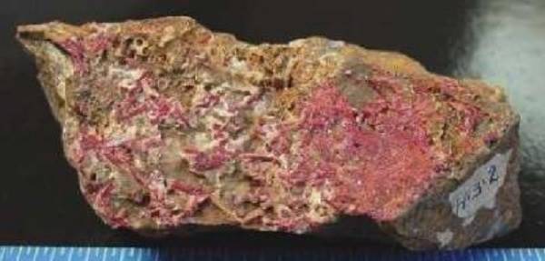
Market Fire 2018 So… You wonder where those Lake county diamonds, obsidian, cinnabar, hot
springs and steam wells come from? Read On: The
Clear Lake Volcanics erupted during four periods of time beginning at about 2
Ma (million years ago). There is a general decrease in age northward from 2
Ma in the south to about 10,000 years in the north. Geophysical data suggests
there is currently a spherical to cylindrical magma chamber about 8.7 mi in
diameter and about 4.3 mi from the surface. Seismic studies indicate that the
vertical extent is approximately 18.6 mi deep. The complex
eruptive history over the past 2 million years and the 10,000-year age of the
youngest eruption indicate that the Clear Lake magmatic system is not extinct
and that future eruptions are likely. Such a long period of multiple volcanic
events and the large volume (approximately 335 cubic mi) magma chamber
suggest that the Clear Lake system could be in pre caldera early evolutionary
stage. Like other, similar, silicic magma systems, such as Long Valley,
California; Valles, New Mexico, and Yellowstone, Wyoming, large-scale caldera
forming eruptions could erupt huge volumes of ash and tephra leading to
volcanic hazards such as pyroclastic flows. Now you
know where those Lake county diamonds, obsidian, cinnabar, hot springs and
steam wells come from. <<<>>> The
Mayacamas Mountains
make up part of the inner Northern California Coastal Mountain Range and the
name is of Native American origin. The range runs west of Clear lake, Lake
county and east of Ukiah, Mendocino county running for 52 miles from a
northwesterly direction to a southeasterly direction. The highest peak, Cobb
Mountain, reaches 4,724 feet in elevation. Another famous peak in the range
is Mount Saint Helena reaching an elevation of 4,342 feet with its shoulders
in Napa, Sonoma and Lake counties. The range was uplifted as a result of the
2.4-million-year-old Clear Lake Volcanic Field. <<<>>> According
to the Weekly Calistogian we need to back up several hundred years to the
year 250, when Flavia Iulia Helena was born. She was the mother of
Constantine the Great. She was a devout Christian and is credited with
establishing Christianity at the heart of Western civilization. Helena,
famed for her piety, was ultimately granted sainthood. In 1841
Baron Alexander Rotchef visited Fortress Ross. The
Baron brought with him his beautiful and adventurous wife, the Princess
Helena, whose godfather was none other than Czar Nicholas himself. Princess
Helena had been named after Saint Helena and was held in high regard by her
people. The
Princess had seen the mountain from afar and was anxious to get a closer
look. Fortunately for her, a team of Russian scientists had been dispatched
to climb the mountain to collect specimens. She would accompany them, finally
reaching the summit on a clear afternoon. To the west she could see the huge,
blue expanse of the Pacific Ocean, to the east the still snow-capped Sierra.
She stood in awe and reverence for what she knew was a gift from God. As they
raised their flag on the mountaintop, they placed a copper plate inscribed
with their names and the date, June 1841. It was then they named the mountain
“Mount Saint Helena.” <<<>>> Located in a valley, East of present day Middletown, were three
different Native American Indian villages that were situated around a lake
the natives called Wennok. The names of the villages were; "Ka-bool po-goot", "Haw'-hawl-po-goot" and "Sahl-sahl-po-goot". The Native Americans who lived around this
particular lake were appropriately referred to as Wennoks and were members of
a larger band, the Lake Miwoks. They called their home "Oleyome". The natives had lived there for centuries
but since the year 1542 several others had left their footprints on the land
and claimed the land for themselves. One of those claimants was the country
of Spain. <<<>>> Alta
California Then in 1821 Mexico won its independence from Spain and they claimed
all Spanish held lands, which included lake Wennok. The lake was located in
the area that in 1861 would become part of Lake county, California. After
Mexico gained its independence from Spain in 1822, the land they now claimed
north of their homeland was an area called Alta California. That claim was
later defined in 1824. The claim included all of the territory of the modern
U. S. states of California, Nevada and Utah, and parts of Arizona, Wyoming,
Colorado and New Mexico. From 1821 until 1848, the Mexican government would grant ownership to
large parcels of land to favored individuals. These land grants were called
Ranchos. Rancho de Collayomi 1844
(also called Rancho Callayomi), was one of those land grants. It encompassed
three square leagues, or 8242 acres in the Loconoma Valley. It was given in
1844 by Governor Manuel Micheltorena to Robert T.
Ridley. Robert T. Ridley was an English sailor, who reportedly jumped
ship, and who became captain of the Port of San Francisco. He married a woman
from a local family which gave him favored status. It was reported that he
was a colorful man, a heavy drinker and involved in the local politics of
Yerba Buena. Ridley was never really interested in his Rancho, so a short
time later he traded his three league Rancho to Jacob P. Leese for the two
league Rancho Canada de Guadalupe la Visitacion y Rodeo Viejo near San Francisco.
Rancho de Guenoc 1845 was granted May 8, 1845,
by Mexican Governor Pio Pico to George Rock. It comprised six square leagues,
or 21,220.03 acres and included Wennok lake. 1847: “First book of
deeds and alcalde records, Sonoma County, California 13 January 1847 – From:
Jacob P Lease to George Rock, witness Richard Fowler.” In this deed, George
Rock, for $300, grants Rancho Guenoc to Jacob P Lease. (Bancroft)
Jacob
Primer Leese was born August 19th,
1809 in Saint Clairsville, Belmont County, Ohio. At
about the age of 20 he started with a party for Texas and then to New Mexico,
and after remaining there for some time he came on horseback to California.
He arrived in California on the 24th of December, 1833, ending his four year
journey in Los Angeles. But
some 17 months later he was on the move again and in May of 1835 he left Los
Angeles on the Mexican, square rigged, two-masted sailing ship called the Arachucha, and after a voyage of six days the vessel
anchored in the sheltered cove of Yerba Buena, now San Francisco. Leese entered into a mercantile
partnership with Monterey businessmen Nathan Spear and William Sturgis
Hinckley, and in Yerba Buena, there, opened a store. The partners ran a
profitable business, trading merchandise for rancho products.
Being
well-received by the officers of the Mexican Government, Leese was given a
choice of land anywhere 550 feet (200 varas) from
the beach line. He selected a site which now forms the southwest corner of
Dupont and Clay Streets, and on this site he built the first frame building
erected on this peninsula. Until this time everyone had lived in and done
business out of tents. It was a clinker-built storehouse, 60x20, and it was
finished on the morning of the 4th of July, 1836. Naturalized, Jacob Leese, on the 1st
of April, 1837, asked a sister of General Mariano Guadalupe Vallejo to become
his wife. On the 7th of the same month they were married, and on the 15th of
April of the following year he became the father of a daughter, Rosalie, who
was the first child born in Yerba Buena. In
1838 Leese’s business partnership with Spear and Hinckley ended. In 1841, Leese sold his business
interests to Hudson's Bay Company, and moved to his Sonoma ranch, still
retaining extensive land holdings in Yerba Buena. Leese served as alcalde (a
mayor having judicial powers) in Sonoma (1844-1845). Leese and his wife were also major
land holders in Monterey County; among their claims was Rancho Sausal, deeded
to Rosalia by her brother Mariano G. Vallejo. Documents
show that in 1836, a man from lower Canada appeared in Sonoma testifying
against a horse thief. This man’s name was George Rock. It
has been implied that George Rock, while in Sonoma during this time, was an
employee of Jacob P. Leese and it was during this time Rock was granted
Rancho de Guenoc which bordered Leese’s Rancho Collayomi
grant. By 1848 George Rock was
running Leese’s cattle operation as “agent for Leese” on Leese’s two land
grants with headquarters located in Coyote Valley. The acreage of the two
grants combined was about 29,500. This acreage included the Loconoma Valley,
Long Valley, Coyote Valley and Guenoc Valley. <<<>>> The Loconoma Valley extends from the foot of
Mt. St. Helena to the foot of Cobb Mountain. It is about ten miles long, and
from one and one half to five miles wide. The Loconoma connected to Long Valley that extended East about
six miles all the way to the Guenoc Valley where Wennok lake was
located. Running through the heart of the Coyote Valley, north of
Loconoma, was a large stream that today is called Putah Creek. The
name “Putah” is of Native American origin meaning “grassy creek”. However,
the name has always stirred controversy because the derogatory Spanish word
for a female sex worker is “puta”. But according to Erwin Gudde (1889–1969),
the resemblance is "purely accidental". Putah Creek is, however, depicted on a French map from 1844 as
“Young’s River”. This map was created by a French naturalist, Eugène Duflot de Mofras and was
published in Paris. It was called Young’s River because Ewing Young, a famous
trapper, trapped up the river from the Sacramento Valley on his way to the
Pacific coast. That was in March of 1833. (Kenneth L. Holmes (1967). Ewing
Young: Master Trapper. Portland, Oregon: Binsford
and Mort, Publishers. p. 87). At the end
of the Mexican–American War in 1848, most of the areas formerly comprising
Alta California were ceded to the United States in the Treaty of Guadalupe
Hidalgo. This treaty also provided
that the Mexican land grants would be honored. <<<>>> Gold! 1848 On January
24, 1848, just days after the signing of the treaty with Mexico, James Wilson
Marshall, a carpenter originally from New Jersey, was working to build a
water-powered sawmill for John Sutter, when he found flakes of gold in the
American River near Coloma, California. At the time
of his discovery, the population of the territory consisted of 6,500
Californios (people of Spanish or Mexican decent); 700 foreigners (primarily
Americans); and 150,000 Native Americans (barely half the number that had
been there when Spanish settlers arrived in 1769). Throughout
1849, people around the United States (mostly men) borrowed money, mortgaged
their property or spent their life savings to make the arduous journey to
California. Thousands of would-be
gold miners, known as ’49ers’, traveled overland across the mountains or by
sea, sailing to Panama or even around Cape Horn, the southernmost point of
South America to reach the gold fields. Not all
gold was found in nugget or flake form. Some was in ore deposits mixed with
silver and other elements. The ore needed to be processed to extract the
precious metals. Mercury was needed to do that and the mineral cinnabar, when
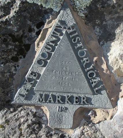
processed, gives up its mercury. <<<>>> 1850 California
becomes a State The First
Road Into Lake County 1850 The first
road into Lake county, called the Old Soldier road or the Emigrant road, was
built by the United States Army in 1850. “Road” meaning it would accommodate
a wheeled utility vehicle such as a wagon. The Army built the road as they needed to bring wagons and cannon into Lake
county to respond to the murder of Andy Kelsey and Charlie Stone by the local
natives. The murders happened in the Big Valley (Kelseyville) area near Clear
Lake. The Army
first traveled from Benicia to the Napa Valley. Then they went over Howell
Mountain and down into Pope Valley. They travelled through the valley to
where the modern day Aetna Springs area is, then west over the mountains.
Next dropping down into the valley that accommodated Wennok lake, the
namesake of The need for
the wagons was to haul whaling boats that were needed as the natives had
taken refuge on an island at the northwest end of the lake. Ultimately
this exercise would be remembered for its horrific massacre not for building the first road into Lake
county. The Army’s action is remembered as: “The Bloody Island Massacre.” The
military vehicles were the first wheeled vehicles ever in this new country. “The Bloody Island
Massacre” In the
“History of Napa and Lake Counties, California”, by Slocum, Bowen & Co.
Publishers, 1881, they relay the story of Kelsey and Stone, their deaths and
the following result. They give two accounts. One is the white man’s version
and one from the Indian Chief, Augustine. I think the
main point everyone agrees on is; Kelsey and Stone brought their deaths to
their own door-step. I quote
from the recorded story: “the death of these two men was the result of
their own folly and indifference to the simplest laws of justice and
mercy." Unfortunately,
their righteous deaths brought an act of retribution that lives in infamy and
makes today’s society struggle trying to comprehend such a brutal act of
vengeance. It was due
to the following historical episode that the first “road” into Lake county
was built. Here is a
synopsis. In the fall
of 1847 some frontiersmen named Shirland, Charles Stone and the brothers Andy
and Ben Kelsey purchased from Salvador Vallejo all of his stock he was
running at Clear Lake. They also secured the right to use the land which he
claimed as a pasture. The Indians
had worked for the Spaniards and Mexicans and were inclined to work for the
white men, Kelsey and Stone, expecting the same treatment they had received
from the previous patrons. Instead,
Kelsey and Stone treated the native Indians as slaves, paying them with
trinkets and very little food. At one point they even secured Chief
Augustine’s wife, took her for their own and refused to allow her any type of
relationship with her legal husband. There is a
lot to this story and many others have already told it, but suffice it to
say, Kelsey and Stone got their just deserts.
Andy Kelsey
died as the result of an arrow piercing his body. Stone had his head caved in
by a rock. Both men were buried in the sand of a caved in creek bank. At first
the Indians expected retaliation but when it didn’t come immediately they
grew less wary. But before long, death was on the march headed for Clear
Lake. The Army
was sent to wipe out those they thought responsible for the murder of two
white men. Never mind that these two white men supposedly whipped and shot
Indians for sport to entertain their guests. In early
1850 the army headed for Clear Lake but upon arriving, found the Indians had
taken refuge on an island in the lake. The
regiment sent a detachment back to secure two whaling boats so they could
access the island. Upon the
detachments return with the boats, the forces now including civilians, split
up. One group with the cannon stayed on the south side of the lake while the
others took the boats and traveled to the north side. In the
morning, the soldiers on the southside raised a raucous. The Indians,
curious, came to the water’s edge to see what was going on. The soldiers
fired their weapons, the projectiles falling way short of their targets. The
Indians began to laugh and jeer the soldiers only to have the response be the
boom of the field cannons. Those projectiles mowed down several Indians as
they cut swaths through their ranks. Frightened
and in disarray the Indians fled to the other side of the island only to meet
soldiers rising out of the tules who killed men, women, children and the
elderly. As those
trying to escape were dispatched, “the Bloody Island Massacre” was completed. No one
knows exactly how many Indians were murdered during the attack on the island
but a fair estimate is 75. However, this action was just their first attack.
The soldiers traveled on into Mendocino county slaughtering several more
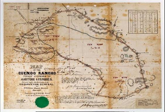
Natives. <<<>>> As required by the Land Act of 1851, a claim for Rancho Collayomi was filed with the Public Land Commission in
1852, and the grant was patented to Archibald A. Ritchie and Paul S. Forbes
in 1863. DAILY ALTA
CALIFORNIA 1/31/1852 Tuesday,
Jan. 27 1852 Messrs. Halleck, Peachy & Billings presented the claim of
Archibald A. Ritchie and Paul S. Forbes, to the rancho de Guenoc, in the old
Sonoma jurisdiction, containing six leagues under a grant made by Gov. Pio
Pico in 1845. SACRAMENTO
DAILY UNION 10/4/1852 On Friday
Commissioner Wilson delivered the
opinion of the Board in case No. 4, A. A. Ritchie and Paul S. Forbes,
claimants of three leagues of land in Napa county, called "Callayomi.
The ' grant was made in June, 1844, by Gov. Micheltorrena
to Robert Ridley, and was approved by the Departmental Assembly on the 26th
of September 1845 In 1838,
Capt. Ritchie left the sea to become the resident agent at Canton, China, for
the Philadelphia import house of Platt and Son. His wife and children joined
him in Macao, near Canton. The Ritchies lived in China until 1847, when they
returned to Philadelphia. Paul Sieman
Forbes arrived in Canton, China in 1843 as U.S. consul and was admitted as a
partner into Russell & Company in 1844. There is no
information that definitely identifies the Paul S. Forbes that was A. A.
Ritchie’s partner, however, due to then existing circumstances, it has been
speculated that Paul S Forbes was really Paul Sieman Forbes of New York as
both Ritchie and Forbes were living in Canton, China at the same time and
both were involved in the same trade. Ritchie was killed in an accident in 1856. Paul Forbes sold his share
of both Rancho Guenoc and Rancho Collayomi to one
of Ritchie's sons-in-laws, Gen. M.D.L. Simpson, in 1867. The following year,
Simpson deeded half the lands to Ritchie's wife, Martha and children. The
heirs began selling portions of the properties in the early 1870s. <<<>>> First Settlers in Coyote
Valley 1852 In 1852 on the north side
of Coyote Valley, which is within the bounds of the Rancho de Guenoc land
grant, J. Broome Smith built a log house. In 1854 R. H. Sterling
and Captain Steele built a stone house near the same spot. Sterling had a family
with him, and his wife was the first woman in the valley. W. H. Manlove, T. Hall, Henry Bond, —
Barnes, W. G. Cannon, L. B. Tremper, B. F. Miles and James S. Miles were old
settlers in Coyote Valley. (History of Napa and Lake Counties, California
1881) Soon others would settle
on the lands encompassed by the land grants. <<<>>> James
Harbin 1856 Around 1856, a settler
named James Harbin assumed control of the land where Harbin Hot Springs is
located, and bestowed his name upon both the springs and the adjacent Harbin
Mountain. That same year he erected a sawmill that would eventually be known
as the McKinley mill. Harbin’s tenure at the
springs didn’t last long, and by 1870, the next owner, Richard Williams, had
built the Harbin Springs Health and Pleasure Resort on this location. "Uncle Jimmy Harbin
named the Truckee river. He was the locator of the famous Harbin Springs, in
Lake County, and was the father of Mat. Harbin, now in Mexico. James Harbin
died last year at his residence in Lake County." - Independent Calistogian
(October 16, 1878) Mill Site Dedicated The site of the historic McKinley
Mill, originally built in 1856, was dedicated three miles north of
here yesterday. James Harbin, who erected
the saw mill later sold to James Amsberry and Jim Davis who operated the mill
until the timber was cut out. Later operated as a flour
or Grist mill by Jessup and Stevens then Heyser and Crothers, the mill was
then managed by Joe Stoddard until it burned in 1885. Andrew Rocca erected
another mill at the site in 1887. George McKinley assumed ownership in 1889
and then turned it over to a family corporation known as the McKinley Brothers in
1908. The old mill building
stood until a year or so ago when it was razed as a fire hazard and a danger
to visitors, and because vandals had virtually ruined all salvageable
material. An electric generator run
by water power at the mill's creek side location, added in 1906, originally
was planned to serve light and power to Middletown. Believed the first public
electric system in Lake County, it was called the Callayomi and Middletown
Light and Power Company. Gene Farmer, Middletown
resident attending the rites, was one of those who used to ride horseback to
the McKinley Mill to have grain and flour ground. Sheldon Bell, manager:
of the Diamond D Ranch, lands which now includes the McKinley Mill site, said
the old stone wheels used in the mill
were shipped “around the Horn” in early days. Mrs. Sue Hillman
president of Clear Lake Parlor 135, NDGW at Middletown and supervisor Earle
Wrieden assisted with the dedication program. The Middletown High
School Band played selections. A brief history of the mill was given by Moss
A. Hunt, and the invocation and benediction by the Rev. George Warman. <<<>>> In 1857 Springston and
Dickson moved to the Loconoma Valley from Cobb Valley where they first
settled. Springston or Butts had the first family in the
Valley. Name: Donald Springston Birth Date: 25 Dec 1901 Birth Place: California,
United States of America Death Date: 17 Nov 1950 Death Place: Lake County,
California, United States of America Cemetery: Middletown
Cemetery Burial or Cremation
Place: Middletown, Lake County, California, Spouse: Mary Margaret
Springston <<<>>>
Was born in
Henry County, Tennessee on November 25th, 1827. He moved to
Missouri where he met and married Elizabeth Ann Hawkins on December 20th,
1849. In the 1850
Census Alexander and Elizabeth were counted as living in Cass county,
Missouri. She was 20 he was 23. In 1851, still in Missouri, they had a baby
girl they named Anna Elizabeth. By 1854 they had moved to Bear Valley,
Mariposa County, California where their second child, a son, was born on
February 22nd. In 1855 they had another son. In 1857
they were living in the Clear Lake township of Napa county. They were one of
the first families to reside in the Loconoma valley. They soon squatted on
land that was part of the Guenoc land grant near the eastern border. They
were forced to move so they moved south and east down the canyon that now
bears their name. In her
book, “Join me in Paradise” subtitled “The History Of Guenoc Valley” © 1982,
published by Guenoc Winery, on page 3, the author, Suzanne Case, stated that “They
built a home at the mouth of what came to be called Butts creek in Snell
Valley.” In the
agricultural census taken June 1st, 1860, A. H. Butts claims to
have owned 200 acres of land valued at
$1,000 with furnishings and equipment valued at $100. To also own 40 head or
horses, 8 milk cows, 6 oxen, 100 head of cattle, 200 pigs with a total value
of $3,560. They also had 2 more children. In the
“History of Napa and Lake Counties by Slocum, Bowen & Co. Publishers,
1881” on page 161 it says; on November 15th, 1861, A. H. Butts
along with others organized the first quicksilver mining company in Napa
county, the Phoenix Mining Company. By 1864 the
family had moved to central California. Mrs. A. H.
Butts, Elizabeth Ann, passed June 4th, 1889 in Cathey Valley, Mariposa, California. In 1900, at
the age of 73, A. H. Butts was living with his daughter and son-in-law in
Fresno, California. HANFORD
SENTINAL 6/25/1903 A. H.
Butts, a man in charge of a pumping station, at Fomosa, was found dead at
that place in Kern county yesterday. The coroner was called to investigate
the case. Alexander
Houston Butts died June 24th, 1903. His remains are buried in the
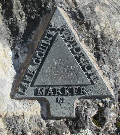
Union Cemetery, Bakersfield, Kern County, California. <<<>>> Kayote 1859 The settlement of Kayote
was located in the Kayote Valley, not to be confused with Coyote Valley and
of which no one is quite sure where it was, except it was along the first
road built into Lake county coming from the south and east. This old road
intersects with present day Butts Canyon Road, built 1860-62, about 7 miles
east of present day Middletown and eventually becomes Grange road in Coyote
Valley The Kayote
Post Office was established in 1859 and at that time would have been
in Napa County. The post office was discontinued on September 20th,
1862. There were only two postmasters. John Kean was appointed July 15,
1859 and he was replaced by O. A. Munn on July 5th, 1861. Kean was
from Ohio and appears in the 1860 census. He was born about 1830 and his
residence was shown as being in the Clear Lake township of Napa county. Kayote Post
Office was the earliest in the area as the Guenoc Post Office wasn’t
established until 1867, five years after the closing of the Kayote Post
Office. The Guenoc Post Office was discontinued in 1880 when the village of
Guenoc moved to Middletown. <<<>>> 1860 The Village of Guenoc In the late 1850s into the early 1860s a small village sprung up on
the south side of Putah Creek in Coyote Valley they called Guenoc. The
village was officially recognized as such when it 1867 it had a designated
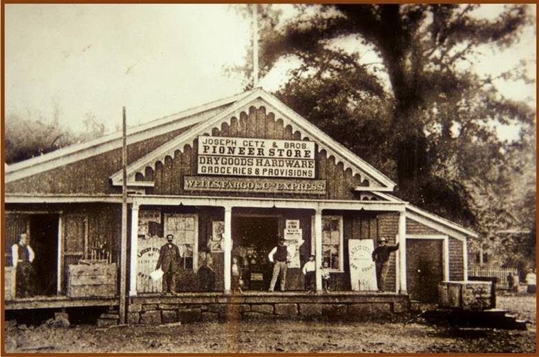
Post Office. <<<>>> Herrick
& Getz 1860 Joseph Getz
was the second born son of Abraham and Sarah (Cohn) Getz. He was born in Zempelburg, West Prussia in the year 1835. By 1856 Joseph
had six brothers and a sister. However, by that time, he was in the United
States. He arrived in the U.S. on the ship; P. J. Behnck,
on July 13th, 1852 along with two brothers, Marcus and Max. Their
entry point was New York City. On the way
west the brothers stopped in Grass Valley and were in the business of
barbering. Joseph and Max moved on and before 1860 the brothers were
in Lower Lake, California. Over the next ten years the entire family would
come to California from Prussia. The mother and father along with several of
the children would settle in San Francisco. Around 1860
Joseph and Max went into business with Hamlin N. Herrick and they opened a
general merchandise store in Coyote Valley. All three men were counted in the
1860 census. It didn’t go so well and the Getzs
moved back to Lower Lake. <<<>>>
<<<>>> Hamlin
Nelson Herrick,
was a 49er. Born in Kentucky in 1827, Hamlin N. Herrick was 22 when he struck out for California.
He actually wound up farming in the Napa area for several years. He eventually re-located to Lake county where
he became a merchant and acquired several hundred acres of land. He then
went back to farming. He settled
in the Lower Lake area around 1860. He was appointed Postmaster of Lower Lake
October 22nd, 1860. He, along with Joseph and Max Getz, opened a
general merchandise store in Lower Lake and another near the northwest end of
Coyote Valley. In 1862,
Hamlin N. married Mary Elizabeth Akins. Mary was the sister of Augustus Akins
who was then employed by Herrick and Getz. Together they had six children.
The first born was daughter Clara, then her brothers; Hamlin Webster, Ossian
Revere, Augustus Middleton, Silas Byrd and Edward L. Clara, the oldest, was
born in 1863. Edward, the youngest was born in 1875. <<<>>> John Brandt is counted in the 1860
census as being a resident of Clear Lake, Napa county his Post Office address
was Kayote and his occupation was rancher. In the 1870
census his residence was Lower Lake and he listed his occupation as shepherd. On January
5th, 1872 John P. Brandt received his land patent for 170.98 acres in the
area we presently call Bohn Valley within the present day Guenoc Ranch
boundaries. This patent was the first patent recorded for the area. His
mother, Margaret D. Brandt received her patent February 20th, 1872 for 160
acres on the east side of Bohn Valley. Both received one other land patent in
the same vicinity. In 1880 he
is counted in Coyote valley and list his occupation as sheep raiser. He is
now raising sheep on 660 acres in the Bohn Valley area. John died
on January 12th, 1881. This left his mother, Margaret, who lived in Napa, to
deal with the sheep and the land now in Lake county. Margaret was then 82
years old. Margaret leased the ranch to Lucien L. Bowen and in 1883 sold the
Ranch to J. B. Richardson and W. N. Bowen of Suisun, Solano county. <<<>>> More about Joseph Getz Augustus M. Akins was a
boy of fourteen when his family settled in Lake county. On April 1st,
1862 he found a job working for Herrick and Getz in Lower Lake. Part of the
time he was engaged in clerking, but he was mostly doing outside work. Joseph Getz
and Hamlin Nelson Herrick had a short lived partnership and soon it was Getz
Brothers with their store in Lower Lake. Joseph
married Johanna Jacobs Oct. 13th, 1864. They had five children of whom two
proceed them in death. In March of
1866 Solomon Getz was in San Francisco and soon traveled to Lower Lake to
work in his brother’s store. He was 16. By 1872 he was running the store and
Joseph had moved to San Francisco to carry on the exporting business. At this
time, Getz’s major exporting and trading partners were in Shanghai and Hong
Kong.
The other
Getz brothers living in Lake county during this time were Marcus, Maurice and
Max. But Max moved on to Sonoma county
where he soon went into the staging business. Pacific
Rural Press ran the following advertisement on September 4th,
1875: “FOR SALE.
A FIRST-CLASS DAIRY FARM AND STOCK RANCH,
Situated in Lake county, twelve miles from the flourishing town of
Lower Lake; containing 880 acres of land, 400 acres of which is choice grain
land, 80 acres of the best natural clover land, and the balance good pasture
land, all of it tinder good fence and divided in seven divisions; abundance
of water and well timbered. Title perfect—U. S. patent. This ranch is
situated in the healthiest part of California, and has been used as a dairy
ranch, where the celebrated Durst's Clear Lake cheese has been manufactured
for a number of years, and is well adapted for that purpose, as also for
grain, sheep and cattle raising. There is on the place a splendid
dwelling-house, two large barns, cheese and milk houses, blacksmith shop,
other out-houses and corrals, and water very handy. Price, $12,000; terms
easy. There is also for sale first-class dairy cows, all the dairy and
farming Implements, etc., at a reasonable price. For further particulars
inquire of JACOB BPORNDLY, on the premises; JOS. GETZ & BROS, Lower Lake;
or GETZ BROS. & CO., Commission Merchants, 513 Front St., San Francisco.” By the
early 1880s Getz Bros. was exporting food products to customers in Shanghai
and Hong Kong, which later led to the opening of the first Getz overseas
office, in Shanghai. The company did well shipping foodstuffs to China, its
reach soon extending beyond Shanghai into northeast China, a populous region
with an appetite for the cheese, oils, and meat products Getz exported. In August
of 1888 Getz Brothers in Lower Lake was dissolved and a new partnership was
formed. The firm’s new name was Joseph Getz and Brothers. I. S. Alexander, of
Lower Lake, was included in the new firm and Joseph Getz became a special
partner. Daily Alta
California January 1st, 1891: “Within the
past two years a new line of steamers has been put on between San Francisco
and the principal Puget Sound ports by Joseph and Louis Getz, of 209 Market
street, this city. At the present tine the firm is running two steamers, the Haytian Republic, of 1300 tons and the St. Paul, of 1100
tons, each accommodating about 130 passengers, and making the passage to the
Sound in three days.” Joseph Getz
died on June 24th, 1896 in San Francisco, California. He was two
months short of being 61. San
Francisco Call July 30th, 1905: “Getz
Bros.' Shanghai Agent Cables Firm to Cancel All Orders. Louis Getz
of Getz Brothers has received a cablegram from Shanghai which he has made public.
The text is as follows: 'Cancel all orders. Boycott of American trade
effective among Chinese merchants. All business entirely suspended." Mr.
Getz says this cablegram was sent by R. H. Van Sant, the manager of the Getz
Brothers' business in Shanghai.” Max died in
Napa on January 9th, 1907. Sometime
between 1900 and 1910 the building that housed the Joseph Getz & Bros.
store in Lower Lake burned down. Augustus Akins, the boy who worked for
Herrick and Getz, bought the lot and built his own successful store in its
place. Today the
Getz Company Website tells this story: The company
started as Getz Bros, a California wholesale store in the mid 1850's to a
formal company in 1871, to off shore trading in the 1880's, to its present
leadership role in marketing and distribution activities. Getz is an
international marketing & services company with over 80 offices in 36
countries around the world. The origins of the company go back to 1852 when
Joseph & Max Getz emigrated from Eastern Europe to the United States.
They started with a small general store in Northern California by selling
local products in and around the San Francisco area. Later they started
exporting goods to China and other Asian countries. Business expanded and
around the turn of the century, Getz opened offices in Shanghai and then Hong
Kong and South-East-Asia. More followed and now it's major offices cover the
whole of the Asia-Pacific region. Over the
years, Getz grew in size and reputation with mergers and acquisitions. New
ventures and businesses developed because of growing collaboration with
business partners. Today, Getz focuses on several core businesses in
international trading, marketing and manufacturing. Abraham
Getz was born on May 24th, 1808 Zempelburg,
West Prussia. He had seven sons and one daughter with Sarah Cohn between 1834
and 1856. He died on May 12, 1890, in San Francisco, California and was
buried in Colma, California. <<<>>> Lake County
Formed in 1861 Most of
what is now Lake County was separated from Napa County in 1861. Small pieces
of Lake County were once in Mendocino County <<<>>> The Journal of William H.
Brewer 1860 - 1864 CHAPTER I THE RAINY SEASON San Francisco. Sunday, January 19, 1862. THE rains continue, and
since I last wrote the floods have been far worse than before. Sacramento and
many other towns and cities have again been overflowed, and after the waters
had abated somewhat they are again up. That doomed city is in all probability
again under water today. The amount of rain that
has fallen is unprecedented in the history of the state. In this city
accurate observations have been kept since July, 1853. For the years since,
ending with July 1 each year, the amount of rain is known. In New York
state—central New York—the average amount is under thirty-eight inches, often
not over thirty-three inches, sometimes as low as twenty-eight inches. This
includes the melted snow. In this city it has been for the eight years
closing last July, 21 inches, the lowest amount 19 inches, the highest 23.
Yet this year, since November 6, when the first shower came, to January 18,
it is thirty-two and three-quarters inches and it is still raining! But this
is not all. Generally twice, sometimes three times, as much falls in the
mining districts on the slopes of the Sierra. This year at Sonora, in
Tuolumne County, between November 11, 1861, and January 14, 1862, seventy-two
inches (six feet) of water has fallen, and in numbers of places over five
feet! And that in a period of two months. As much rain as falls in Ithaca in
two years has fallen in some places in this state in two months. The great central valley
of the state is under water—the Sacramento and San Joaquin valleys—a region
250 to 300 miles long and an average of at least twenty miles wide, a
district of five thousand or six thousand square miles, or probably three to
three and a half millions of acres! Although much of it is not cultivated,
yet a part of it is the garden of the state. Thousands of farms are entirely
under water—cattle starving and drowning. Benevolent societies are
active, boats have been sent up, and thousands are fleeing to this city.
There have been some of the most stupendous charities I have ever seen. An
example will suffice. A week ago today news came down by steamer of a worse
condition at Sacramento than was anticipated. The news came at nine o'clock
at night. Men went to work, and before daylight tons of provisions were
ready—eleven thousand pounds of ham alone were cooked. Before night two
steamers, with over thirty tons of cooked and prepared provisions, twenty-two
tons of clothing, several thousand dollars in money, and boats with crews,
etc., were under way for the devastated city. You can imagine the
effect it must have on the finances and prosperity of the state. The end is
not yet. Many men must fail, times must be hard, state finances disordered. I
shall not be surprised to see our Survey cut off entirely, although I hardly
expect it. It will be cut down, doubtless, and some of the party dismissed. I
see no help, and on whom the blow will fall remains to be seen. I think my
chance is good, if the thing goes on at all, but I feel blue at times. I finished my geological
report on Tuesday, it is 250 pages on large foolscap, besides maps, sketches,
etc. I have my botanical and agricultural work yet to do. San Francisco. Friday, January 31. WE have had very bad
weather since the above was written, but it has cleared up. In this city 37
inches of water has fallen, and at Sonora, in Tuolumne, 102 inches, or 8 ½
feet, at the last dates. These last floods have extended over this whole
coast. At Los Angeles it rained incessantly for twenty-eight days—immense
damage was done—one whole village destroyed. It is supposed that over
one-fourth of all the taxable property of the state has been destroyed. The
legislature has left the capital and has come here, that city being under
water. This will give us a better chance for our appropriation, but still the
prospect looks blue. There is no probability that we will get enough to carry
on work with our full corps. Wednesday, January 29,
was the Chinese New Year, and such a time as they have had! I will bet that
over ten tons of firecrackers have been burned. Their festivities last three
days, closing tonight. This is their great day of the year. They claim that
their great dynasty began 17,500 and some odd years ago a pedigree that beats
even that of the "first families of Virginia." All the roads in the
middle of the state are impassable, so all mails are cut off. We have had no
"Overland" for some weeks, so I can report no new arrivals. The
telegraph also does not work clear through, but news has been coming for the
last two days. In the Sacramento Valley for some distance the tops of the
poles are under water! San Francisco. February 9. I WROTE you by the last
steamer and also sent a paper. I have sent a paper by each steamer for some time
and will send another by this. A mail now occasionally gets in, but many
letters and papers must have been lost. For papers and printed matter the
"Overland” is a total failure. Since I last wrote the
weather has been good and the waters in the great valleys have been receding,
but there is much water still. I have heard many additional items of the
flood. Judge Field, of Sacramento City, said a few days ago that his house
was on the highest land in the city and that the mud was two feet deep in his
parlors after the water went down. Imagine the discomforts arising from such
a condition of things, An old acquaintance, a
buckaroo, came down from a ranch that was overflowed. The floor of their
one-story house was six weeks under water before the house went to pieces. The
"lake" was at that point
sixty miles wide, from the mountains on one side to the hills on the
other. This was in the Sacramento Valley. Steamers ran back over the ranches
fourteen miles from the river, carrying stock, etc., to the hills. Nearly every house and
farm over this immense region is gone. There was such a body of water—250
to 300 miles long and 20 to 60 miles wide, the water ice cold and
muddy—that the winds made high waves which beat the farm homes in pieces.
America has never before seen such desolation by flood as this has been, and
seldom has the Old World seen the like. But the spirits of the
people are rising, and it will make them more careful in the future. The
experience was needed. Had this flood been delayed for ten years the disaster
would have been more than doubled. The telegraph is now in
working order, and we had news this morning-up to 5 P.M. last night from St.
Louis—surely quick work. But the roads will long be impassable over large
portions of the state. <<<>>> Sonoma
Democrat, 29 May 1862 Mr. James M. Finley, of Lake county, without capital and almost unassisted,
opened the Dead Broke mine with his own labor. For two years be has worked with that energy and perseverance that
rightly directed always insures success. <<<>>> In 1852 Moses
James Church loaded up his family, hitched a team of oxen to his wagon
and crossed the great plains, the Sierra Mountains and settled near Stockton
in California. But after a year he removed to Napa County, near present day
Middletown, not far from the head-waters of Putah Creek. This area would
become part of Lake county in 1861. There he embarked in the stock
business. He continued there as a stockman for eight years, and then he took
up his residence in Napa City, built a large blacksmith shop and conducted
that for a couple of years. He sold out and located in Fresno County at
Centerville, and there he engaged in sheep-raising for another two or three
years; and in 1870 he started the canals that made Fresno County famous. A son of
his, Lorenzo Bonaparte Church, who was born as a twin
September 13, 1846, in Lake county, Indiana crossed the plains with his
family as an eight year old. He was reared at the family place near present
day Middletown and from a boy learned the blacksmith trade. In Lower
Lake, California on October 3, 1868, Lorenzo married Mary Josephine
Springston. Josephine Springston was the daughter of William and Nancy Springston
and their family was one of the earliest families to settle in the
Loconoma Valley. Lorenzo and
Mary moved to Fresno county and remained there for about nine months. During
that time baby girl Carrie was born December 11th, 1869. The
family then returned to Lake county where they were counted as residents in
the 1870 census. They homesteaded and preempted east of Middletown, on Putah
Creek. They engaged in raising sheep and Lorenzo bought more land, until he
had over 800 acres. During this time four more children were born. 1871, Carina; 1873, Lola; 1874, Leona and 1876,
Lorenzo Jr. who died at 6 months. The family continued on there until the
spring of 1878, when they sold out to Theron H Ink and re-located in Fresno
County. <<<>>> The
Homestead Act of 1862,
allowed settlement of public lands and required only residence and
improvement and cultivation of the land. Any person, who had never taken up
arms against the U.S. government (including freed slaves after the fourteenth
amendment) who was a citizen or person intending to become a citizen, 21
years of age or older, and the head of a household could make application.
This included women. With five years
residence and improvements/cultivation, only a $15.00 fee was required to get
160 acres. The process had to be complete within seven years. Only the land
that was outside the Land Grant boundaries and that was owned by the Federal
Government was available to homesteaders. <<<>>> Lawley Toll
Road In early
days the only route to travel to the famous Lake County resorts was via
Calistoga and over the Lawley Toll Road on Mount St. Helena. It was in 1866
that a franchise to construct and operate a toll road was granted by the
Legislature to John Lawley, a Mr. Patterson and Henry Boggs and they began to
construct a toll road over the Mount St. Helena gap into Lake County from
Calistoga. He completed this in 1868. <<<>>>
In 1866
there was a William H. Thompson registered to vote in the Coyote Valley
precinct. This person stated he was a
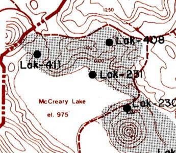
farmer originally from Kentucky and in 1866 he was 38 years old. W. H.
Thompson received a patent for another 160 acres he had been working at the
east end of Amel Lake on July 30th, 1878, apparently just in time
to sell it to Theron Ink. THE WEEKLY
CALISTOGIAN MAY 8, 1878 Mr. W. H.
Thompson has sold his place near Middletown, Lake county, to Supervisor Ink
of this county, for $10,000. Mr. Thompson will soon leave with his family for
Oregon, intending to settle there. <<<>>> B.
F. English
headed for the new county of Lake in California and in June of 1867 Benjamin
Sr. was registered to vote in Coyote Valley, Lake county, California. The
rest of the family, according to the 1870 census, was still in Green Valley.
But then in 1871 Charles Henry was registered to vote in Coyote Valley as
well. By the 1880 Census, Benjamin F. and Pauline L. English are residents of
Middletown, Lake county, California. They are homesteading 120 acres above
Anderson Springs in the Putah Creek drainage near present day Socrates Mine
road. <<<>>> |

Free counters provided by Andale